Geology of our region

No one can possibly walk along our magnificent shoreline and not marvel at the geology on display. It attracts Geologists from all over the world to study its classic examples of complex structures and sedimentary features. So here, in a non-technical way is the longest story possible cut very short.
Together with the guided geology walk, this will add to your pleasure of walking along our many beautiful beaches.
(Our Geology walk is still to be added, but this piece of geological history will greatly help your understanding as you walk our coastline.)

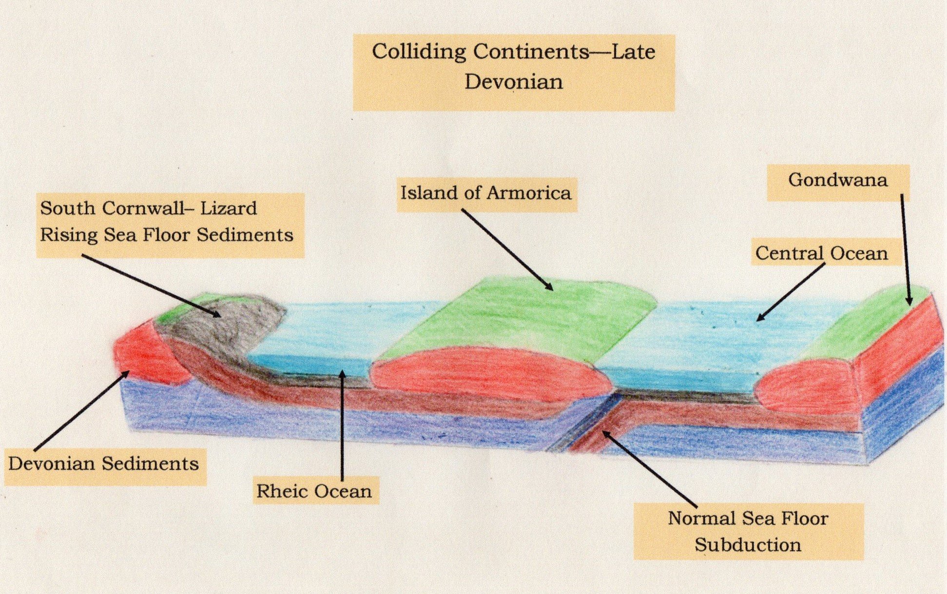
If we could fly over our patch of sky 340 million years ago, the first thing we would notice is that there was nothing but sea – Cornwall did not exist. Looking to the north we would see a huge landmass, Laurasia, its coastline around South Wales. This massive continent included North America and Europe and part of Russia. We would also be looking down on an area of sea that was part of the equally enormous Rheic Ocean.
Turning our gaze south towards where Boscastle and Tintagel exists today, here we have a Caribbean-like Sea of shallow water, with volcanoes spilling out ash and molten lava and bubbles of pillow lava forming in the warm waters, as we are now to the south of the equator. Flying further south the sea becomes very deep, too deep for many of the fishes of the time, but a small single-celled creature called Radiolaria lived and died in these waters, their skeletons sinking to great depths and accumulation as a slimy deposit on the seabed which would eventually form Radiolarian Cherts, a hard, fine grey silt-like rock.

Further south again, a second major landmass is slowly drifting northward, picking up small islands as it progressed. This is Gondwana, which includes South America, Africa, Australia, India and Asia. The two land masses are set to collide with cataclysmic consequences. The collision creating a mountain chain thousands of miles long, across a super continent called Pangaea.
So, this is the picture we would see during the start of the Carboniferous Period, between 360M and 290M years ago. The Carboniferous Period is conveniently divided into two periods, the Lower and Upper. And it is what happens in the Upper Carboniferous that resulted in what we see along our shoreline today.

We should first look at the deposits that are accumulating in our local patch of sea that form what is called the Crackington Formation; these are laid down during the Namurian Period around 326m years ago.
At this time, our area is just to the south of the Equator, with storms and flash floods, high rates of erosion, swampy areas and vegetation; an ideal environment to produce huge quantities of sand, silts and muds; in places, anoxic pools of black muds, shale and plant debris. All this material eventually makes its way out of the landmass of the Laurasian coastline to our north (now South Wales), being discharged by its great rivers, into deltas. These sediments eventually make their way into our patch of sea. Where they end up, depends on the speed of the waters carrying them out to sea and the grain size of the material being carried.

But of course, there is a lot of action also happening to the south. As the Continents collide, mountains form along a northward moving front. As they push forward, sediments wash off the steep face of the mountains, piling up sediments. Some of these sediments had not even consolidated and cascaded down as an unconsolidated mass of stones and muds to form “slump Beds”.
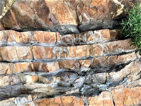
Occasionally, a storm or earthquake dislodges the deposits and these cascade in a tumult down slope building thicker sedimental layers which then settle out. More correctly, they “grade out” settling on the sea floor in the order of their grain weight – the heaviest first, concluding with the very lightest. These sequences repeat over millions of years building up layers of sediments called turbidites – as they result from turbidity currents that flow at speed from the delta fans to the north and mountain faces to the south. It is these deposits that produce the Crackington formation. They occur in the Mid to Upper Carboniferous.
In the photograph we can see the sand deposits being capped with layers of silt and shale. Also, each new sand deposit tends to sink into the soft, unconsolidated, shale layer, creating characteristic bulges on the under face. These will be seen even more dramatically in the Bude Formation later.
Although not visible in the Bude area, the collision of the two Continents farther south does produce very unusual deposits.
Normally, the heavy basalts contained in the sea floors will sink into subduction zones, when they are forced against a Continental mass. This is because Continental rocks are lighter than basalts.
However, at the point of collision in South Cornwall, the sea floor deposits, and part of the mantle, rise above the Continental rocks producing some exotic rocks in the Lizard area today.

Gondwana continues to push northward shrinking the Rheic Ocean to nothing more than an enclosed sea. It is named the Westphalian Sea as it extended with an east-west axis from southern Ireland to Westphalia in Germany.
In our region, the sea floor buckles into a deepening basin with a centre just north of Bude. This results in the sediments lain down during the Crackington Period being exposed to the south and then reappearing further north towards Hartland Quay.
In fact, the Crackington Formation appears rather abruptly at a major fault line, just the south of Widemouth Bay.
We now consider the second set of sedimentation that will settle in our basin, the Bude Formation. These are the deposits that form our cliffs between Widemouth Bay and Marsland Mouth at the Devon border. Understanding this will explain much of what you will see as you walk along our shoreline. We are now talking about the closing period of the Upper Carboniferous, between 313M to 290M years ago.
As we have seen, the Westphalian Sea is being assailed from south and north, but there is an important difference now. To the north a barrier is believed to have formed creating a large lake somewhere in what is now the Bristol Channel. In this lake, or lagoon, sand accumulates in great quantities, and in places dotted with pools of muddy-black shales and plant debris. There are extensive periods of quiet settled conditions with lighter elements of material making its way to the sea and settling is thin beds of silts, grey stones and shales, showing ripples bedding as seen on the beaches today.
But, occasionally, storms in the Westphalian Sea breach the walls of this barrier releasing vast quantities of fresh water and huge quantities of material. These heavy, sand-laden tumults sink beneath the salt water and flow in underwater river channels, created as it picks up more deposits and gains ever increasing speeds.
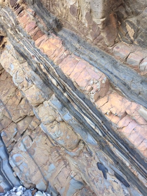
Plotting the course of these deposits show that they appear to head southward and then along the axis of the east-west basin. These avalanches of sand create the Massive Sandstones which are laid down in one event and have no significant grading. These massive sandstone layers are the main characteristic of the Bude Formation.

As the dust settles, so to speak, finer sediments settle out on top of the sandstone layers. The Massive Sandstone, with their great weight, bulge their way into the last set of unconsolidated muds and shale, creating load casts – a useful means of determining whether the beds are as laid down or inverted.
Also visible in this photograph are the flame structures that pierce their way into the overlying sand. This also confirms that the sediments had not had chance to harden between each event.

To complicate the picture a little, sometimes the storms breached an area of lake releasing the brackish shales and muds and these too gushed southwards carrying all before it, including the occasional fish, that was quickly overwhelmed. The picture shows one of the most well-known outcrops at the back of our open-air swimming pool. The swimming pool is known locally as “Saturday Pit”, and this has given its name to the shale band– Saturday Pit Shale.
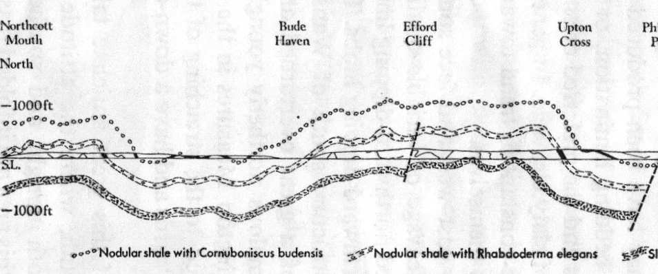
These shale bands with their associated fossils can be dated chronologically and play an important part in the interpretation of the geology of the Bude area, as the shale bands with their fossils can be traced across the exposed cliffs along our shoreline. The illustration opposite shows some of these bands plotted across our shoreline.

Saturday Pit Shale is also famous as it contains a fossil known as the Bude Fish, more correctly called Cornuboniscus budensis. It was first discovered by a group of local school children in the 1930’s. The photo shows an example of this fish taken from the Saturday Pit Shales. The fish are encased in stone-like concretions. This one appears to be gasping for air in the anoxic torrent.
There is also a shale band call “Tom’s Cove Shales” named after the little swimming pool on the end of the breakwater at Bude called Tommy’s Pit – named after Sir Thomas Dyke Acland who built the pool.
If we think of all these sediments building up a pile of deposits thousands of metres thick during the millions of years of the Upper Carboniferous Period, but with dateable shale bands occurring at various stages in this pile, then it may be possible to understand how this helps to understand the stratigraphy. At the bottom of the pile, we have Embury Shale, followed by, Gull Rock Shale, Hartland Quay shale, then Longbeak Shale; Tom’s Cove Shale and Saturday Pit Shales; followed by Sandymouth Shale and finally, at the top of the pile, Warren Gutter Shale.

We have now seen how the basin of the Westphalian Sea was being infilled from north and south. At first creating the Namurian, or Crackington Formation. Then followed by massive sand avalanches from the northern lake creating the Bude Formation.
Of course, there were quieter periods when lesser influxes occurred and also very quiet periods when thin beds of sandstone built upon layer after layer until they were several centimetres thick. (See photo opposite, key fob for size.)
Muds and shales also flowed in various directions cutting across earlier beds - resulting in crossbedding. All will be seen with close examination of the Bude Formation

We saw examples of load casts on the bottom of the thicker sandstone layers earlier. But there is another feature to be seen at the base of some sandstone layers.
As sand avalanches down the sea slopes, it creates eddies or whirlpools which lift out depressions in the sand called “flute casts”. These depressions are filled in with the next sequence of deposits and this results in a characteristic shape on the base of sedimental layers. A smaller version of the load-casts, but these taper off at one end and have a linear sense in the direction of current flow. This “taper off” is because the eddies’ ability to cut a depression decreases as the whirlpool loses energy as it picks up progressively more deposits. Flute casts vary in size considerably, according to the strength of the eddies that form them. The example shown is on the base of fine sandstone layer - not a powerful avalanche of sands.
The large sand avalanches create the most obvious flute-cast features, but they do also occur on the base of lesser silt deposits. The main point to remember is that features will all have the same orientation.

This photograph shows most of the features just been explained and these can be safely seen on the beach at Bude. It also has a small “normal fault” running through its centre. The left-hand side has clearly slipped down slightly as tensions were relived.
Another snapshot across sedimentary beds on the local beach showing fairly thick sandstone with some channelling; infilled with shales and siltstone and some crossbedding. At the bottom right-hand corner of the photo will be seen flakes of shales ripped off by the next influx.
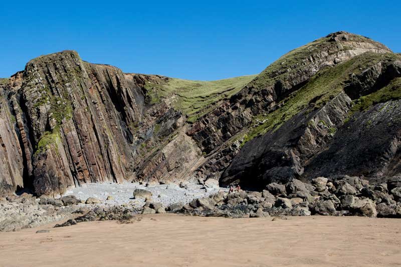
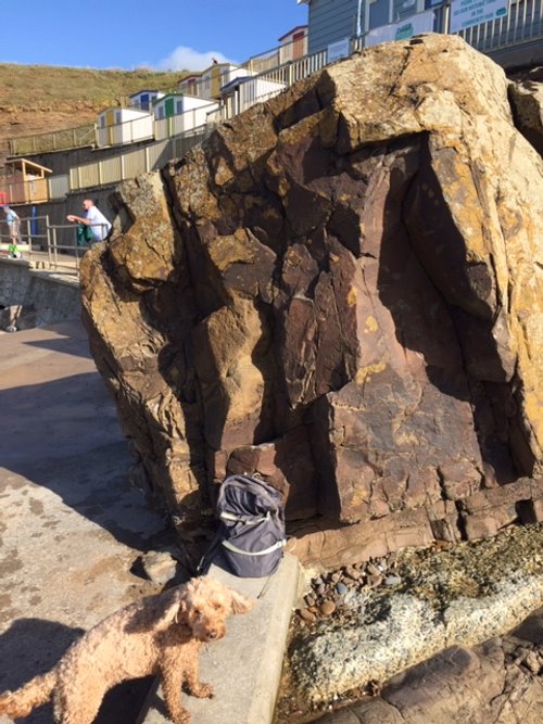
Eventually the Westphalian Sea become filled and the mountain building from the south reached our area. Mountain building now seriously deforms these new sediments in our region during what is called the Variscan Orogeny. Locally, from our beaches today, we see in our cliff-structures, anticlines, synclines, various forms of faulting, strata set on end and slump beds and much more.
The photograph shows a syncline to the left rising to an “A”-shaped anticline to the right.
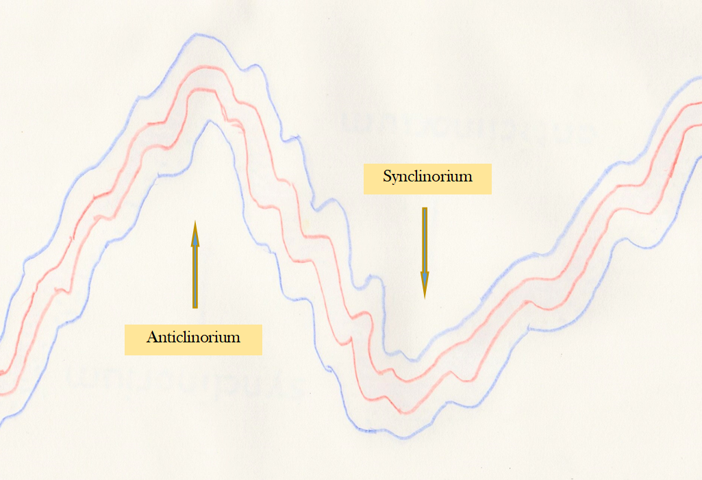
What is not so obvious is that these individual structures represent only one-fold in a greater system of massive proportions; these are the anticlinorium and their opposites, synclinorium. These structures in the Bude Formation have and east-west axis running considerable distances in land. If you cut an imaginary line across these large structures, you will effectively be seeing what has happened along our shoreline.
The anticlinorium at Bude is centred around Embury Beacon to the North of Bude and a less-well defined synclinorium at Sandy Mouth, just up the coast from Bude.

The consequence of these major structures is that they formed mountain of Himalayan proportions having core thicknesses of some 40k. The mountain chain covered much of Pangaea across an east-west axis, the vestiges of which can still be seen in many countries.
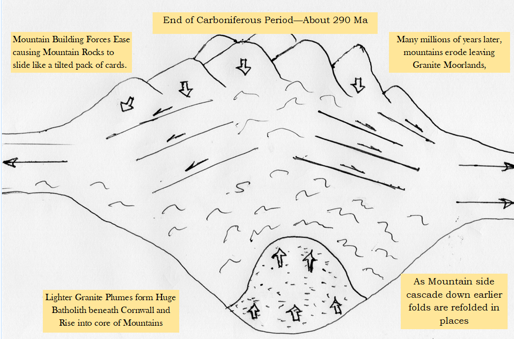
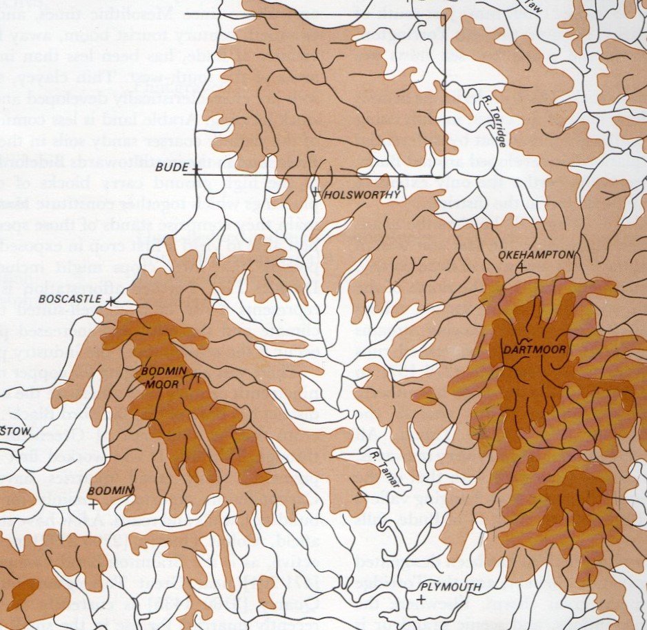
This structure did not just go upwards but also sank, deep into the earth’s mantle. Eventually, the mountain core deposits met with the hot mantle of the earth and began to melt. The molten masses rose up as granite plumes lifting up the country rock and changing the form of the rocks at the point of contact. Beneath Cornwall, these granite plumes rose up from what is thought to be one enormous batholith and over a 30-million-year period created a succession of intrusions that would become the Moors of Cornwall and Dartmoor in Devon. Dartmoor is the oldest at 300-280Ma, Bodmin Moors 290Ma, St Austell 280-270ma and so on. However, the granites of the Isles of Scilly date to 290 to 280Ma.
It should be noted that some of these granite events actually occurred in the very late Carboniferous and into the next Geological Period, the Permian -commencing 290Ma.

The granite intrusions pushed the sedimentary rocks to even farther elevations, to the point that they became unstable. Adding to the instability was the fact that Gondwana, the landmass to the south, stopped moving northwards and the forces, that had caused the mountain building eased. The mass of material held up in the mountains and above the granite intrusions, began to collapse, responding to gravity. Huge chunks of land slid down the mountain faces creating new structures, re-folding some rocks for a second time–seen in this photo at Boscastle Harbour, for example.
The rocks further south also fell back into the earth to disappear completely, forming the English Channel. Cornwall itself would have disappeared without trace had it not been for the granite of the Moors. They are lighter that the typical rocks of a continental mass and the granite acted like a lifebelt holding Cornwall’s head above water. In fact, Cornwall was for a time an island, until further sediments accumulated to the east joining Cornwall to the rest of England.
We have seen that the collision of these two land masses created the super continent of Pangaea but after millions of years it too began the breakup. Greenland broke away, then South America and finally the Atlantic Ocean. The volcanicity associated with this may have contributed to global warming and sea levels rose significantly as there was no ice at Poles. We are now in the Cretaceous Period of 145Ma to 65Ma.

These high sea levels created massive areas where the sediments laid down were eroded away leaving huge, levelled areas called marine-platforms. Locally, these have been identified at 300m, 250-230m and 150-200m, but the Bude coastal area falls mainly in a 60m marine platform, which the Tamar Valley takes advantage of all the way to Plymouth. When you are walking along our coastal paths, the extensive marine platforms will be fairly apparent if you look along the coastline and then further inland – if you ignore the post-glacially eroded valleys.

Now that your attention has been drawn to these major marine platforms, they will become obvious to you as you walk the coastal paths. As will the notches in the cliff faces formed by raised beaches of recent inter-glacial times.
This photograph is looking North over the Breakwater at Bude (high tide) from which the common level of the land, top right, will be apparent.

This has been a summary of the events creating the sediments, the sedimentary features and the forces that deformed the rocks along our beaches. They are comparatively straightforward in the Bude area; they become progressively more complex further south. It is not possible here to delve into these complexities, but at Millook, just to the south of Widemouth Bay, there is a structure known world-wide. The next page will explain this further.

It is best explained by looking at the photograph opposite. Essentially, chunks of the land mass to the south slipped forward in wedges which dragged the anticlinal structures into “recumbent folds” causing the folded structures to plunge down upon themselves to form zig-zag folding- some now inverted.
The Geologist who resolved this structure explained to the author, many years ago, that he drew the sedimentary layers on a pack of cards and tilted them until the pattern seen in this illustration became apparent.
Millook is situated where the wedges meet the green over-folding.

All that has been written has given the impression that this happened a very long time ago. However, all the processes described are still happening today. Coastal erosion of course, but the rocks themselves are still moving and we do get earthquakes at times, as Cornwall and Europe adjusts to present and past forces. The Alps are still rising- although possibly being eroded at the same rate as the rising but this does create modern instability.
Our region is covered in minor and major faults, the most obvious of which is the wrench-fault that runs right along our beaches at Bude.
The final point to have in mind when looking at geology locally, is that the horizontal distance has been greatly shortened by all this folding. So Bude to Tintagel, for example, was at least twice as great as today.
Hopefully, this wide-sweeping summary of our geology will help you to understand what you will see as you walk our cliffs and shoreline. Within the “Walks” menu there is a walk around the Bude Beaches that will help you to further understand our geology. However, during the summer months a renowned Geologist will take you on guided walks around Bude and you should enquire about these from our Tourist Information Office at the Crescent, Bude. Details again from the drop-down menu.
If you enjoy reading about our history without any adverts appearing, please help me to meet all the cost with a small donation by clicking on the link below.
For extra security, the link below will take you directly to the Paypal payment centre without an intermediate stage.
For more details of how this donation will benefit you and young local people to our area, please select “info” on the menu button.
Your payment will be much appreciated, however small, thank you.