The Ice Ages
Our local history cannot be fully understood without reference, at least, to the last two great Ice Ages, and the warm periods in between.
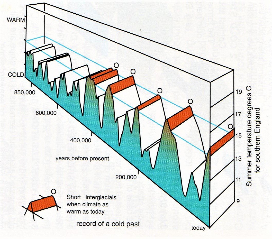
Note: refer to “Bude in the Brone Age” to see how our planet’s relationship to the sun can predispose us to cold and warm periods. It should be mentioned too that whilst these periods extended over thousands of years, that is not the only perspective. There is clear evidence to suggest that cold and warm periods also occurred over quite short periods- perhaps just between five and ten years and even less if influenced by volcanic activity. We are thinking here of cold water flowing down from melting ice sheets cutting off the warm water of the Gulf Stream or, conversely, the re-establishment of the Gulf Stream.
(Image Courtesy of Peter Keene, Thematic Trails)
In terms of features to be seen in our modern landscape, we must go back to the Wolstonian Ice Age of around 380,000 years ago. The ice sheet during this period extended down to at least south of Cornwall and the Isles of Scilly, with fingers of ice feeding into North Devon; the ice also flowed over the top of Lundy Island leaving it with the flat-topped profile that can be seen today.

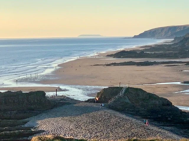
Hartland Quay Truncated Valleys. Photo courtesy of Peter Keene from his book, “ The North-West Devon Coast”
A finger of this glacier also flowed into the Taw-Torridge estuary depositing boulder clays and blocking off the local rivers. The dammed-up rivers of the Yeo, Taw and Torridge created a lake which eventually over spilled and found its way to the sea by a circuitous route, resulting in abandoned meander valleys to be seen today running parallel to the cliffs at Hartland Quay and Strawberry Water. (See Hartland Quay Walks.)

The weight of the ice compressed the land significantly. There were warm periods at times, but the Wolstonian finally came to an end around 130,000 years ago and the ice began to melt.
The land then began to rebound towards its old contours, but not quite; as, around 125,000 years ago a particularly warm snap melted the ice faster than the rebound and the sea rose around 7 to 13 metres above modern levels, cutting raised beaches in the cliff line. These can be seen as notches in our modern cliff line, or as pebble deposits, as at Westward Ho! - see photo courtesy of Peter Keene of Thematic Trails.

Boscastle Harbour
At the entrance to Boscastle Harbour, just to the south of Bude, we can see the modern “lower” wave-cut notch and above it the same shape is repeated. This is the feature we see along most of our North Cornwall Cliffs. Also, at Boscastle, the complex hard rock structure resisted erosion and the ice meltwaters cut a deep narrow Port entrance resulted.
At Bude, the local farmers confirm finding seashells at this contour in their fields and we can also see the remnants of a fossil cliff alongside the Bude Canal seen from the Peter Truscott Bridge.
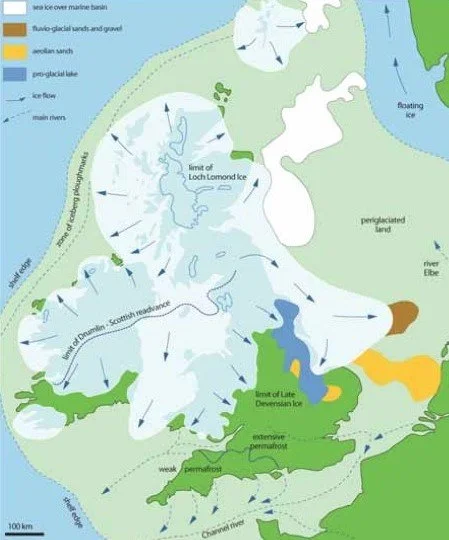
Around 10,000 years later, that is 115,000 years ago, another Ice Age commenced. This is known as the Devensian Ice Age.
The ice on this occasion extended down to the southern coast of South Wales and Southern Ireland. At its deepest centre, around Rannoch Moor, Scotland, the land sank 250 metres while, ironically, the land around North Cornwall rose; this is due to a natural seesaw phenomenon. However, this does mean that today, Scotland is still rising at at Bude the land is sinking at around 2mm per year- not good as global sea levels rise!
So much water was locked up in the ice that the sea level dropped between 120 to 150 metres below present. This would mean that the shoreline would have extended out to the location of the Continental Slope or Shelf Edge and, presumably, out of site from our present land.
The English Channel then had the combined flow of several major rivers cutting a deep water channel and, the same would apply in the Bristol Channel. Exiting the estuaries of North Cornwall and Bude would also be deep water channels leading to the distant shoreline.
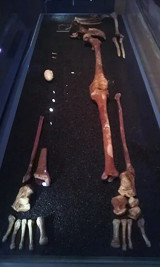
Despite the very cold conditions, hunter-gatherers are known to have hunted their prey in Britain around 40,000 years ago and some of these groups would have walked along our coastline all the way to South Wales; one man in such a group, around 30,000 years ago met his death while hunting at the ice front in South Wales. This is the famous Cro-Magnon “Red Lady of Paviland” human skeleton, which was covered in red ochre, found in Goat’s Hole Cave at Paviland, South Wales in 1823. (See Photo.) The person who found the skeleton concluded it was the remains of a female- let’s just say for various reasons. However, modern analysis has shown the skeleton to be that of a male aged around twenty-five years. Around 20,000-18,000 years ago, conditions during the Devensian Ice Age became so bad that even these summer hunting parties had to abandon their forays in Britain.
Note: There was a brief warming spell around the period 40,000 to 30,000 years ago and clearly the Cro-Magnon people took advantage of this to venture northward.
The other significant outcome is that rivers flowing off the land during major melts cut deep channels along the estuaries of North Cornwall and North Devon. Studies have shown deep-cut riverbeds beneath the mouths of the Bristol Channel and Barnstaple estuary. The meltwaters flowing into the Ocean at this time appears to have deflected the Gulf Stream and caused a further mini–Ice Age around 9000 years ago. In Scotland, this is known as the Perth re-advance.
Fossil Forest- Crooklets Beach
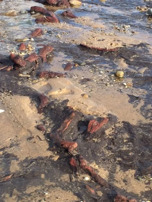
The estuary at Bude would then be very different to today. The old cliff line would have been fossilised and farther westward than present. Of course, the shoreline as such would have been a long way westward. The River Neet would be flowing strong in the wetter conditions as the flaw took hold and this too would have cut a deep channel towards the sea. At Crooklets Beach, as the climate warmed, a mini forest started to form attracting wild animals and hunter-gatherers. In fact, the estuary around 5000 years ago would be at least half a kilometre longer than present day. The land, relative to the sea would be much higher that today, due to the ice bulge.
(Image shows the remnants of the fossilised wood at Crooklets Beach, exposed following a winter storm.)
Around the 6000 years ago, when sea levels came closer to those of today the early seafarers would avail themselves of our harbour at Bude as a refuge from threatening storms, or to provision their stocks for onward travels. The Bude harbour, with deeper water and a cliff line further westward than today, may well have been more accommodating than we now envisage. Of course, the mini forest at Crooklets Beach would soon be overcome by the rising sea and the cliff line would again be exposed to the forces of the Atlantic waves. The wavecut platform we see on the beach today may be around the location of the fossilised Ice Age cliff line.
One modern remnant of that last great Ice Age is that the land in Scotland is still re-establishing it old pre-Ice Age contour, rising at around 3mm per year, whereas in North Cornwall we are sinking at 2mm per year- not good news as sea levels rise due to global warming!
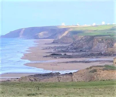
(This photo conveniently shows more notches in our local cliffs and also on the foreshore the wave-cut platform which roughly equates to the line of the cliffs during the last Ice Age.)

This image shows our local beach at Summerleaze around 30000 years ago during the Devensian Ice Age, when our forts human visitors came here to hunt.
This page shows one image that has been commissioned to tell our local story in ever greater detail.
This whole section will be enlarged and will benefit from new research in the coming months and this is an example of how reader donations will help in this task.
(see next page)
If you enjoy reading about our history without any adverts appearing, please help me to meet all the cost with a small donation.
For extra security, the link below will take you directly to the Paypal payment centre without an intermediate stage.
For more details of how this donation will benefit you and young local people to our area, please select “info” on the menu button.
Your payment will be much appreciated, however small, thank you.