Rough Tor, Bodmin Moor
This is an easy walk involving around twenty minutes of up hill walking, leading to the top of the second highest hill in Cornwall. Pronounced Row Tor, it would most probably have been a sacred hill in Neolithic and Bronze Age times. You are entering a world unchanged for thousands of years with some of the best preserved historical remains in England. It is strongly advised that you read the history content relating to the Tor to understand better the features you will discover. On reaching the saddle you are now within the ancient Tor Enclosure and can walk to the left or right along the saddle to discover all that the hill has to offer. From here you can see the greater part of Cornwall and North Devon.
Strong footwear is recommended as hidden stones in the smooth path may twist an ankle and present major rescue considerations in this comparatively remote location. Also, within the Tor are numerous rocky outcrops to negotiate.
Please carry a map and compass for your safety but navigation on this walk is a simple matter of noting the bearing back down to the car park. Also refer to the info menu for more details of all safety considerations.
Rough Tor. From here the Neolithic people could look down over all their terrain and marvel at the natural forces that created this outcrop.
As you contemplate this comparatively simple walk you can view this simply as an exercise with wonderful views. Equally, you may prefer to understand what the hill would mean to the early people for whom the hill had great meaning.
You will have driven to the car park through a largely treeless landscape and arrived at a modern scene of people, fenced off areas, gates and bridges. For the Mesolithic people the journey was quite an undertaking, through significant forests, with the anticipation of hunting the animals that would nourish their families for the months ahead. Later Neolithic and early Bronze Age people would be driving their animals here to benefit from the summer pastures and later still, meeting with their family members who lived here permanently.
At certain times of the year the visit may have been for great ceremony, celebration, gathering to trade and compare experiences; different tribes or communities gathering for the first time and who will have approached the hill, from various defined pathways, honouring the cultural rituals along alignments and stone circles during their progress.
If we think we, today, are beyond such things, think again as you view cairns marking your path up mountains; on beaches piles of stones constructed into carefully balance features, or here on Rough Tor, you may find a modern-day miniature stone circles built by someone for whom it might be just a casual construction with little meaning, but if that person returned year on year, or generation upon generation then that stone circle creation will take on more meaning. This is what happened on Bodmin Moor and, because Rough Tor was such a prominent feature in the landscape, visible from almost all low-lying areas, it developed huge ritual significance to the point that it became sacred, to be fully understood only by those with special knowledge or powers.
For these early peoples, who had such close association with nature, who lived in a world full of mystery, these huge Tor structures must have filled them with awe; the huge vistas from the hill tops looking out over the forest to the sea, perhaps watching the rising or setting of the sun. It is not difficult to imagine the impact such an experience would have on the mind of the community and its cohesive, collective, powers.
Our walk starts from the small footbridge below the car parks and will lead out to the start of, what is now believed to be a Neolithic Procession Way.

This picture shows the main features of this walk
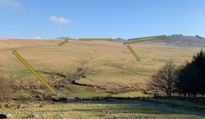
This shows the suggested route. Starting from the small footbridge below the car park. This photograph is taken from the car park. Just hidden behind the tree to the right of the picture is the Charlotte Dymond memorial - more about that later.
The spiritual value of this location may have been one of the reasons for the Temperance Society who organised gatherings on these western slopes of Rough Tor in 1843 and 1844. The first meeting attracted around 3000 people, the second possibly as many as 10,000.
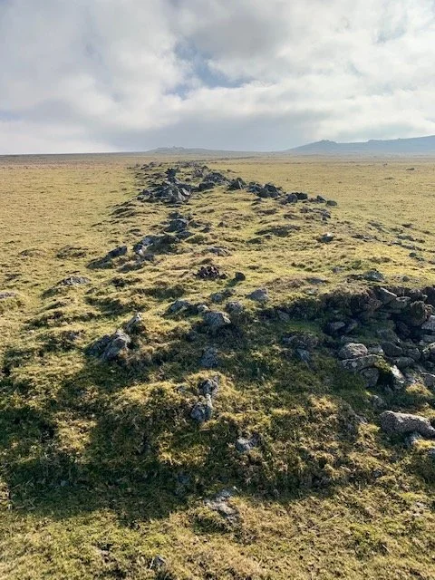
From the small foot bridge below the car park head upwards and slightly to left to meet with the procession way. Originally this was thought to be a marker barrier between to communities, but recent studies realised this was most probably a ritual procession way to the Tors. The T.V. Time Team carried out studies here a few years ago and dated this to the Neolithic.
The Neolithic people would have emerged from the woods of Oak and Hazel with the prospect of the hill ahead. This was probably in the later Neolithic when the hill had taken on a spiritual significance of great antiquity and heritage.
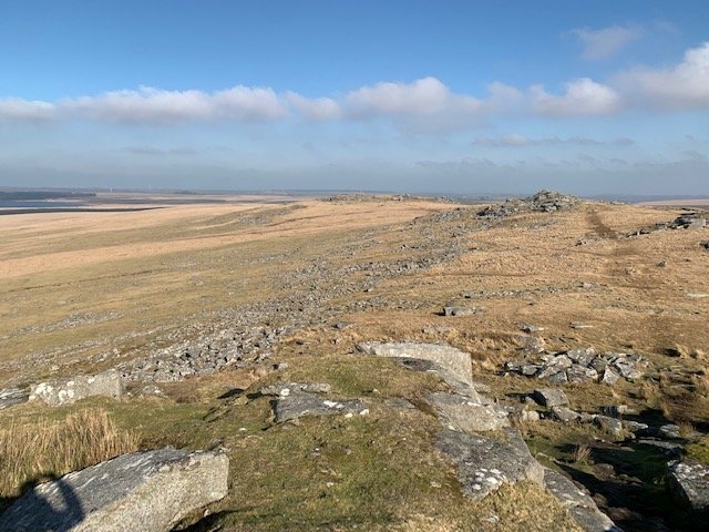
The side support stone, or orthostates, supported the sides of the path with the central core of smaller rubble.
The path curves towards Little Rough Tor and as you walk up the hill, It is worth looking back and reflecting on the work commitment involved in this, which demonstrates the value that was attributed to this procession way.

From the procession way continue your walk to Showery Tor, standing proud on the left-hand side of the saddle. You will be presented with the image on the left. The huge cairn, one of the larges on the Moor, encircles the central Tor as if to add to its meaning and power.
The views all around and especially to the northwest from here are spectacular. It must have had huge significance to the Neolithic people.

This view is of Showery Tor looking westward. It gives a slightly better impression of how the cairn encircled the Tor. Of course, it is much denuded in size and height.
Further over to the right, beyond the rocks in this view will be seen a number of small holes drilled by miners in the flat-lying rock from where they set gunpowder to create celebratory fireworks.
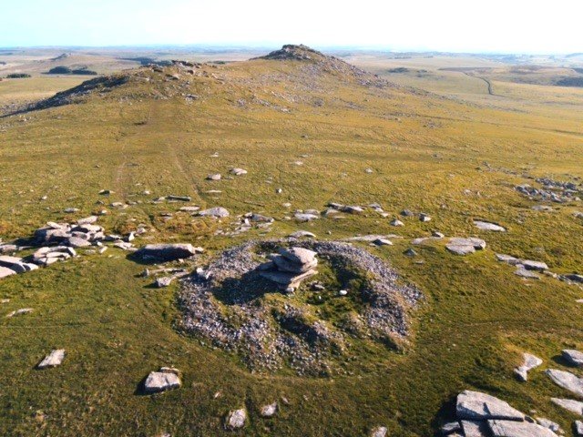
This drone shot taken from the Cornish History site shows Showery Tor cairn very clearly, plus a distinct outer ring of stones. If you zoom in to the central cairn there are two weathered hollows that look intriguing.
From Showery Tor head south across the saddle to Little Rough Tor - that’s the next hill along the saddle. On your left you have Brown Willy; in Cornish, 'Bronn Wennili', which means 'Hill of Swallows.
To the south west you can see Louden Hill and the flat moorland of King Arthur’s Downs where there are three stone circles that had great significance during the late Neolithic and early Bronze Age -two of which are on Stannon Downs.
On the 1st of May the rising sun passes through a slot in the rocks of Rough Tor to shine down on one of the Stannon Stone circles.
Little Rough Tor stands proud on the saddle as you head towards Rough Tor itself. It too was surrounded in a cairn to add to its splendour and meaning. The stones of the cairn are now much denuded apart from the modern pile that modern man still finds a compulsion to add the stone and a wish.
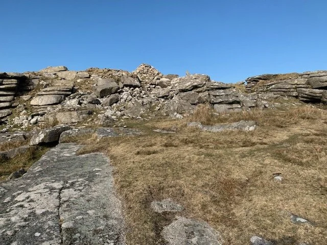
From here, as you head further south across the saddle you enter the ancient Neolithic Tor Enclosure. You may spot flat areas devoid of stones where the Neolithic people built wooden huts for temporary shelter- possibly during summer monitoring of their animals or during special celebrations.
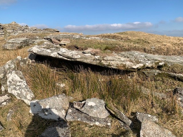
Much of the material for these walks have been gleaned from the research of others. This image comes from Johnson and Rose 1994.
It shows the Tor Enclosure stone walling to your left and right as you walk across to Rough Tor. The left of this image are the elaborate entrances. The small dotted areas are where are the bases cleared of stones for wooden huts. Later Bronze Age people changed the nature of the Enclosure and included burial cairns and huts within the enclosure.
Unfortunately, it is difficult to discern all the features shown here as the structures are badly denuded.
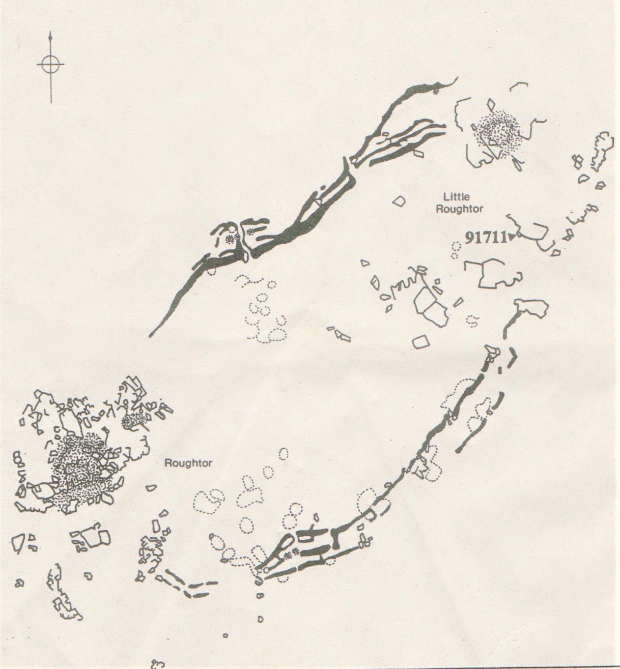
The item marked as 91711 on this image is shown on the next page.
Little Rough Tor will be seen in the background of this image of the feature identified as 91711 by Johnson and Rose. In this photograph it’s shape is not obvious but when you find it on your walk it becomes much clearer.
The archaeologist detail this as a cist or Medieval/Post-medieval shelter. Frankly, it looks a little more like a shelter of the type used by those monitoring the summer grazing flocks. It’s for you to judge.
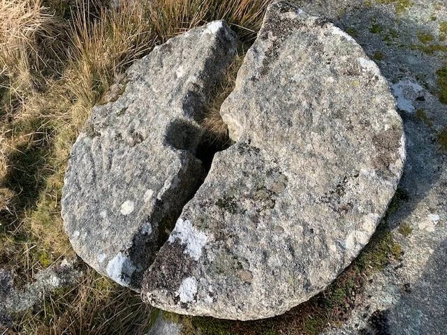
As you walk away from the shelter/cairn you arrive at two outcrops of rock, just east of these at SX14820 80889 will be found this unsuccessful attempt at fashioning a granite millstone.
One can imagine someone walking up to the Tor searching out a suitable piece of granite then, over a number of days, maybe in inclement weather, chiselling away to shape the piece. And then, one hit with the hammer too many and it split in to two. The air was probably quite thick with more than mist that day!
As you walk across the area of the Tor enclosure look out for patches of ground devoid of stones where, probably, were built wooden huts by those taking part in the Neolithic gatherings.

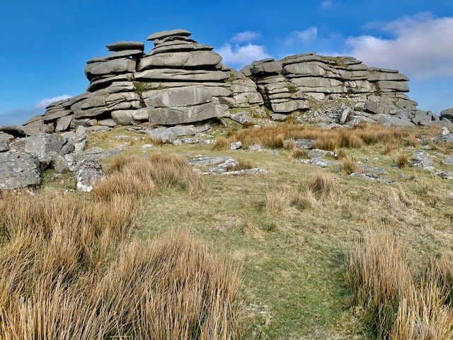
Continue walking towards Rough Tor which comprises two massive outcrops. Take care as you make you way up between rocks. Children will love all the hideaways and hidden caves. Eventually, you will find a path down into the inner area of the Tor; between the two large outcrops. Again, there are remains of cairns alongside the main tors. This area has such a powerful presence it is not difficult to image its impact of the early peoples who came here.
If you walk just to the left (west) of the Tor in this photo you will have a wonderful panorama of the whole coast of North Cornwall and you can also look down on the villages and various walls and drove ways on the western slopes of the Tor.
When you have soaked up the atmosphere of the main Tor outcrops head back the way you came until you have the view opposite. This is looking north-eastward from Rough Tor back to little Rough Tor and Showery Tor. Down on the left are the jumble of rocks or clitter that orginally made up the Tor Enclosure walls. Amongst them are Bronze Age cists and the remains of stone huts.
When you arrive at the western side of little Rough Tor head down slope for around 150m to the Holy Well.
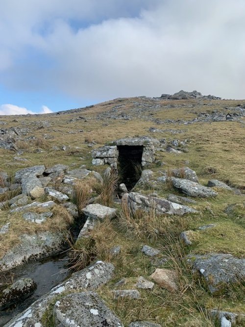
This is the, so called, Holy Well that may have been used by a hermit living in St Michael’s Chapel on the southern slopes of Rough Tor. It is now a vestige of its original self, its stones having been displaced around the County.
The chapel may date back as early as 1200AD and was built by the Peverells, Lords of the local Manor of Hamatethy. The hermit Priest most probably met the spiritual needs of the Peverells but also would have been a guiding presence for those crossing the Moor along the Davidstow to Blisland route.. There is also a possibility that the hermit Priests could see across to a similar Chapel on Roche Rock way off to the south west in the parish of Roche, near Bodmin. Maybe he could pass on or a relay signals of danger. The chapel would have gone out of use with the Reformation.
The well was buried in bracken and only in recent times uncovered to its present state.
A visit to St Michael’s Chapel will be included with the walk to Fernacre Stone circle and the Bronze Age and Medieval villages there.

From the Holy Well seek out the swathe of Moorland patch created by the many feet that have headed down to the Bronze Age villages.
On the way look out for the walls that surround the villages and what looks like a large “Reave” boundary that defined the home areas from the summer routes to open pastures (opposite). Animals would have been driven up the drove ways to the higher ground for the summer where they were attended permanently by the young of the village. The term “Reave” often relates to similar hedges on Dartmoor but are sometime used here on Bodmin Moor. A glance at the Ordnance Survey map of these location shows these reaves and walls clearly.
It is now a simple walk among the many houses and village enclosures. Some of these may date back to the Neolithic, but are mostly Bronze Age. One looks as if it was re-occupied during the Medieval period.
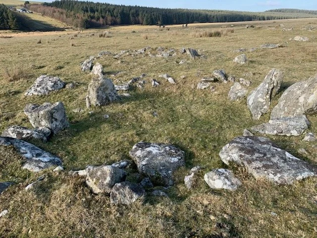
This is one of the many houses to be seen as you make your way through the villages. A few of the edging stones have fallen into the building and the two large upright stones on the left show where the entrance was, facing south west.
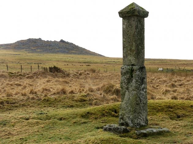
As you make your way back to the bridge and the car park, you will see nestling beside the small stream a monument.
This is the Charlotte Dymond monument who was, supposedly, murdered as she walked the route from Davidstow to Blisland in 1844. Her death and the subsequent hanging of the suspect murderer attracted much publicity.
At the start of this walk, is a mention of the Temperance meeting here in 1843. A second meeting was held here in July 1844, three months after Charlotte’s murder. It is said that ten thousand people turned up and this attracted lots of side events- possibly including lots of drinking!!
A collection was taken and this paid for a monument to commemorate her death - or was it to reinforce the message that she was murdered?
The historian, Pat Munn has written a book entitled , “The Charlotte Dymond Murder, Cornwall 1844. If you are intrigued, it is suggested that you obtain a copy and you can make up your own mind.
If you are taking this walk in the summer time, you may wish to cool your feet in the stream and just soak in the peace and quiet of the location.
There are two other walks yet to explore to complete the trio written from this location.
If you enjoy reading about our history without any adverts appearing, please help me to meet all the cost with a small donation.
For extra security, the link below will take you directly to the Paypal payment centre without an intermediate stage.
For more details of how this donation will benefit you and young local people to our area, please select “info” on the menu button.
Your payment will be much appreciated, however small, thank you.